Showing posts with label ozarks. Show all posts

Monday, February 6, 2012

Pea Ridge #3 - A Cold Winter on the Ozark Plateau

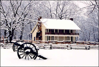
Elkhorn Tavern in the Snow
National Park Service
This is part three of a six week long series commemorating the 150th anniversary of the Battle of Pea Ridge, Arkansas. To read the two previous posts, click Pea Ridge #1 and Pea Ridge #2.
The winter of 1861-1862 was remarkably cold in the Ozarks region of northern Arkansas, even though it was strangely warm deeper in the Deep South.

From Alabama and Mississippi, for example, there were reports that meat was spoiling because there had been no proper "hog killing weather." In Arkansas, however, the snows were piling up. Letters written home to Louisiana by soldiers serving under Colonel Louis Hebert, for example, described snow accumulating to depths of between one and two feet in Benton County.

Ice Storm at Pea Ridge Battlefield
National park Service
The men serving in Northwest Arkansas that winter, however, were reasonably well-housed and well-equipped. Winter quarters in the Cross Hollows area between Fayetteville and Bentonville were strongly constructed of sawed lumber and the thousands of men camped there were sheltered from the cold wind, sleet and snow the characterized that winter. Most described their cabins as "comfortable."

They also were as well-fed as any army in the field at that time. The Arkansas River had been running high through the winter, allowing steamboat traffic to continue at a brisk pace between Little Rock and Fort Smith. The latter city was a major supply center for Confederate troops serving in the West and a steady stream of supply wagons made its way up and over the Boston Mountains with provisions, clothing, shoes, weapons and other necessities for the troops in Washington and Benton Counties.

Gen. Earl Van Dorn, CSA
Sickness was also diminishing in the camps. Most of the men had now served long enough for their systems to adapt to the rigors and stresses of service in the field.

Meanwhile, elsewhere in Arkansas, General Earl Van Dorn had arrived in Pocahontas and appeals had been issued for the men of Arkansas to enlist in his army as quickly as possible. In every county of the state, new companies were forming and preparing to march in response to the calls of General Van Dorn and Governor Rector. An army was forming of sufficient size to approach the Union onslaught that was expected to come down from Missouri in the spring.

I will continue posting on the 150th anniversary of the Battle of Pea Ridge over coming days and weeks, so please check back often. You can read more about the battle anytime at www.exploresouthernhistory.com/pearidgeindex.

Friday, January 27, 2012

January 27, 1862 - Gunpowder Mining in the Ozarks

Cave in the Arkansas Ozarks
In a previous post on Civil War industry in Arkansas (see Industry in Arkansas on the eve of the Pea Ridge Campaign), mention was made of the development of caves in the state as a source of raw materials for making gunpowder.

To field its armies, the Confederacy of course needed gunpowder and surveys conducted in Arkansas by Dale David Owens during the years before the war proved that the Ozarks contained some of North America's finest deposits for mining saltpeter.

Saltpeter (often spelled saltpetre in old documents) is another name for potassium nitrate. This mineral is key to the production of gunpowder and was found in the limestone caves of the Ozarks. These caves riddle the hills in the northern half of the state and by the time the Pea Ridge Campaign began to develop in late January of 1862, saltpeter mining was developing as a major industry in Arkansas:
Ozark Mountains of Arkansas

...We sometime ago gave an account of the saltpetre caves of Arkansas, and stated that machinery was being sent from this city [i.e. Memphis] for working some of the caves up White river; so successful has been the experiment that the Jacksonport Herald states that a Mr. Carlton ships about a ton and a half of saltpeter every week to Nashville, to be made into powder, and that he soon expects to ship two and three tons per week.

This account, from the Memphis Appeal, was published in late January of 1862 and was picked up by newspapers throughout the South as evidence of the growing capability of the Southern war effort.

The article mentioned the White River, one of several areas in Arkansas where saltpeter mining took place. Additional mines were located in Newton County and elsewhere. The mineral was prepared on site at mines like the one in Boxley and then carried by wagon or ox cart to the Arkansas or White Rivers. From there steamboat transportation was available to carry it own to powderworks throughout the South.

The Pea River Campaign would spell the beginning of the end of saltpeter mining in Arkansas. By firmly planting themselves in Northwest Arkansas, the Federals opened the door for raids on mining operations in the Ozarks. As a result, the importance of Arkansas saltpeter to the Confederacy would diminish rapidly following the Battle of Pea Ridge.

I will continue posting on the 150th anniversary of the Pea Ridge Campaign over coming days and weeks, so be sure to check back often. You can also read more on the Battle of Pea Ridge at www.exploresouthernhistory.com/pearidgeindex.

Tuesday, September 13, 2011

Pig Trail Scenic Byway - Ozark National Forest, Arkansas

Pig Trail Scenic Byway
With college football back in play, weekend traffic is once again heavy on the Natural State's famed Pig Trail Scenic Byway.

The beautiful two-lane highway cuts through the Ozarks, providing a short cut from Interstate 40 at Ozark to Fayetteville, home of the state's beloved University of Arkansas Razorbacks (affectionally known as the Hogs or Pigs). Because of the large number of fans decked out in Razorback Red and the University of Arkansas banners, flags and decals that adorn the lines of cars that pass up and down the highway on football weekends, it has been affectionately (and officially) dubbed the Pig Trail.

Pig Trail Falls
Part of State Highway 22, the Pig Trail actually has a long and colorful history. It originated as an Indian trail that wound its way down out of the mountains to the present site of Ozark on the Arkansas River. Early French trappers and fur traders likely gave the region its Ozarks name (corrupted from the French expression Aux Arcs, which is thought to have referred to the great bend of the river at Ozark). They likely followed this same route up into the mountains as long ago as the 1600s.

It later became an important trail and then road for early settlers of the region and during the Civil War was used by both Union and Confederate troops.

Now part of the Ozark National Forest, the Pig Trail is one of the most beautiful fall drives in the state and is known for its stunning scenery, waterfalls and as an access route to the famed Mulberry River.

To learn more, please visit www.exploresouthernhistory.com/pigtrail.

Friday, June 24, 2011

War on Civilians in the Ozarks - The Depopulation of the Mountains

The Ozarks
While many stories are told of Sherman's March to the Sea and other campaigns, nowhere in the South did attrocities against civilians approach what happened in the Ozarks of Arkansas and southern Missouri during the Civil War.

Many of the mountain people had no interest at all in the war and most just wanted to be left alone. They had moved west to the Ozarks in search of country that they liked and the isolation and freedom that life in the mountains offered them.

When war came, however, the very isolation of the mountain communities and homes made them easy prey for a reign of terror waged by soldiers and guerrillas from both sides and outlaws who came only to raid, rob and destroy. By the winter of 1864-1865, in fact, so many of the mountain people had been killed, burned out or driven away that the Ozarks presented a scene of desolation unparalleled in American history.

Elkhorn Tavern
Built on Ruins of Tavern burned by Guerrillas
The following account of a report by a postal official appeared in a South Carolina newspaper:

In the resumption of mail service in the South, continued evidence of the despoliation of the land is brought out. An employee of the Post Office Department, now superintending mail matters in Arkansas, writes that “on the mail route from Fort Smith, in that State, to Caswell, in Missouri, there is not a house nor habitation where a mail carrier could refresh himself or beast, in a distance of nearly two hundred miles. From Fayetteville to Caswell, by the old mail road, the distance is seventy-five miles, and there is not a house or garden fence left standing, nor a field under cultivation. - Keowee Courier, November 11, 1864.

The terrorism inflicted on the people of the Ozarks would continue for many years after the war, with guerrilla bands and outlaws roaming almost at will through the region.

Some places to learn about some of the destruction in the region include War Eagle Mill and Blue Spring Heritage Center in Northwest Arkansas. Both were the locations of important water mills destroyed during the war. The famed Elkhorn Tavern at Pea Ridge battlefield in Benton County was also destroyed by guerrillas the year after the battle. The present structure was rebuilt on the ruins after the war ended. To learn more, please follow these links:

Friday, July 16, 2010

Ozark National Forest is rich in Historic Sites

Sweeping across much of the northwestern quarter of Arkansas, the Ozark National Forest preserves some of the most scenic and historic land in the Natural State.

Not only is the forest home to sweeping mountain vistas, rugged hills and valleys, waterfalls and the famed Mulberry River, it is rich in historic sites and landmarks. At unexpected places in the forest, hikers come across long-forgotten stone fences and traces of old home places, many of which date back to before the Civil War.

The Ozark National Forest was the scene of untold numbers of skirmishes and raids during the war. Not only did regular troops move back and forth along the roads leading through the mountains, the hills of the Ozarks provided shelter and hiding places for the guerrilla bands that ravaged much of the state. These men - some of whom supported the Union and others the Confederacy - in many cases employed increasingly brutal tactics against both military and civilian targets alike.

The forest is today accessed by such famed Arkansas highways as Scenic Highway 7 and the Pig Trail Scenic Byway. Both take visitors past beautiful scenery and through some of the most stunning country in the South. There are numerous parks, recreation eras, overlooks, campgrounds, picnic areas and landmarks.

To learn more, please visit www.exploresouthernhistory.com/ozarknf.

Saturday, March 21, 2009

Eureka Springs, Arkansas


If you plan to do some Civil War site exploring in Northwest Arkansas, a good base for doing so is the beautiful and historic community of Eureka Springs.

Less than 30 miles from Pea Ridge National Military Park on U.S. Highway 62, Eureka Springs is a major Spring travel destination in the Ozarks. There are a number of sites in the area with Civil War connections, including Pea Ridge, Blue Spring Heritage Center, War Eagle Mill and the Buffalo River area. Eureka Springs itself is a well-preserved Victorian era community noted for its amazing array of historic structures that range from America's "Most Haunted Hotel" to Thorncrown Chapel, an architectural landmark.

The city boasts a wide array of hotels, bed and breakfast inns, cabins and even treehouses as well as restaurants, cafes, unique shops and a variety of points of interest. Eureka Springs is also the per capita wedding capital of the United States. More people go there to get married each year than actually live in the town!

To learn more, please visit www.exploresouthernhistory.com/eurekaindex.

Thursday, February 12, 2009

Pig Trail Scenic Byway - Arkansas


This 19 mile scenic highway passes through the Ozark National Forest in western Arkansas and provides an outstanding chance to see the mountain country of the Ozarks as it appeared to Union and Confederate soldiers that passed along the same route.

Call the Pig Trail because it has long been popular with fans of the University of Arkansas Razorbacks as they travel to and from games in Fayetteville, the scenic highway follows a route that has been used since the earliest days of settlement in Arkansas.

Brigadier General W.L. Cabell passed along this route with 900 men in 1863 on an expedition that ended at the Battle of Fayetteville. The road was used throughout the war by both regular forces and the guerrilla bands that hid deep in the mountains and emerged to strike at both regular forces and citizens holding viewpoints opposite their own.

Today the Pig Trail is one of the most beautiful roadways in Arkansas. It winds through picturesque mountain valleys and passes waterfalls, running streams, rock formations and the rolling hills of the Ozarks. To learn more, please visit www.exploresouthernhistory.com/pigtrail.

Saturday, February 23, 2008

The Boston Mountains, Part Two


Continuing our look at the Boston Mountains of Arkansas, this view looks from a ridge across the valley of Cove Creek.
A major Civil War landmark, Cove Creek flows south through the Boston Mountains from the Ozark Plateau of Washington and Benton Counties into Crawford County on the Arkansas River. It merges with Lee Creek in northern Crawford County and flows into the Arkansas River at Van Buren.
The valley provided a natural route through the mountains for the movement of large bodies of troops. Confederate troops followed Cove Creek on numerous occasions, most notably during the days leading up to the Battle of Prairie Grove. Federal troops, in turn, used the valley to move south prior to the fights at Dripping Springs and Van Buren.

Wednesday, February 20, 2008

Eureka Springs, Arkansas


Although the city itself dates from the post-Civil War years, you will find bits and pieces of Union and Confederate history around Eureka Springs, Arkansas.
The beautiful little Victorian city is a major Southern destination and a great place to stay if you are exploring the Civil War sites of Northwest Arkansas and Southern Missouri.
I've just launched a new Eureka Springs section that you might find of interest at www.exploresouthernhistory.com. Just follow the link and look for the heading on the main page.

Tuesday, January 15, 2008

Prairie Grove Battlefield - Ozarks Village


The first section of the Battlefield Trail at Prairie Grove Battlefield passes through a fascinating collection of historic structures saved from locations around the Ozark Plateau. None of these buildings were originally on the battlefield, but they were saved by the community and relocated to the site to provide visitors with a good understanding of the normal homes, churches and schools in the region during the Civil War. Beautifully restored and maintained, the village represents one of the few places that life in the Ozarks as it was lived during the 1860s can still be experienced.
The village area does not intrude on the primary battlefield and provides an interesting step back in time for visitors as they leave the modern park facilities around the visitor center and begin their walk through the battlefield.
We will continue our look at Prairie Grove over the next few days with more photographs and postings. In the meantime, visit www.exploresouthernhistory.com for more information on the battlefield. Just scroll down the page to the index and you will see the link under the "Arkansas" heading.